
Safe Pass plotting, why not?
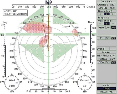
Fred Pot showed me a really interesting new concept in target plotting that was developed at a Dutch maritime school. Currently many plotters/PCs and radars can automatically use ARPA and/or AIS info to calculate the CPA (Closest Point of Approach) and TCPA (Time of CPA) for vessels within range. Typically they flash a warning if a potential CPA drops below a preset threshold like 1 mile, meaning that you and the other vessel are going to pass that close if you both maintain current course and speed. This is all good—and beats the hell out of manual plotting—but still leaves the operator to figure out how to change course/speed to avoid tight CPAs, which can get especially complicated when there are multiple vessels involved. “Safe Pass” works a little like computerized weather routing, calculating various CPA/TCPA data versus possible changes in your course and then plotting potential safe, and dangerous, areas ahead. In the example above, bigger here, you are about to cross a shipping lane with two vessels crossing each way. Turning left will make things worse, but turning right between the red “danger clouds” will result in a safe passage (assuming the other vessels maintain course and speed). The concept seems to make a lot of sense, and has purportedly tested well in ship simulators (at that Dutch school), but so far no developer is yet working to make it available. I wonder why not?


Agreed !!
Sorry to disappoint you but Y-Tronic has included this capability in their Yacht-AIS software. For a display of this (done under simulation so I could make my boat do 68 knots) go to http://yachtvalhalla.net/photos/yachtaisdisplay.jpg
Too many good ideas die in the inbox of somebody’s General Counsel. His or her idea of safety is minimizing exposure to liability, not collision.
Looks like an interesting feature but it seems to me that the same info can be had by watching the CPA and TCPA of the target. The situation should be clear by noting if they are ascending, descending or holding stable. Am I missing something
There is a limit to what the computer can do. The Windows Resource Meter is a good way to tell what the load is. For maximum reliability of the charting system, the meter should show about 1 or 2% when the program is showing the GPS position on a chart, then when you throw in a few hundred AIS and ARPA targets, it may leap to 5% or 6%. Anything more than that and the reliability is in question. So while the Safe Pass type of feature looks spiffy at the boat shows, I don’t think the compromises to reliability are worth it.