
ECS roundup, your suggestions please!
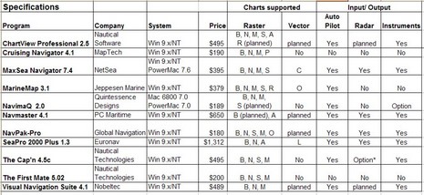
I was so wet behind the ears! One my first attempts at magazine writing was an overview of Electronic Charting Systems (ECS) for the Sept/Oct 1999 issue of Ocean Navigator. I spent months doing the research, actually installing and testing all eleven programs above (table bigger here), and wrote some 11,000 words on the subject. I recall that ON was surprised at the size of it, but published almost the whole thing (some is still online, titled “Power navigation”, though you’ll need a subscription to read it).
At any rate—though I’ve tried to avoid big overview articles, particularly about ECS, ever since—I’m about to write one for Sail (which I’ll probably modify at some point for PMY). I’ve got to fit it in 2,000 words/six pages, and my idea is to highlight a good selection of particularly well done features, hopefully in as many different programs as possible. It goes with the idea that there is no perfect program for everyone, and that you can learn a lot about what’s possible via diligent shopping. I’d love your help. What do you think Nobeltec VNS, or Coastal Navigator, or RayTech or whatever does particularly well? And what ECS features are important to you, anyway? Please post ideas in the comments or just e-mail me. Developer comments welcome too.


I’ve used Maxsea, then converted to Coastal Explorer. Briefly, what I like about CE:
1. The user interface “feels right” to anyone used to Windows.
2. Seamless quilting of vector and raster charts.
3. Included AIS functionality.
4. Included, seamless (cliche, yes, but what the heck), access to US-only photo images from Terraserver. Overlayable on charts.
5. Easy downloading and import of US Noaa ENC charts.
6. Terrific chart portfolio management function. Determine what charts are were on your PC, whether they should be displayed, etc.
7. Very robust! Almost never hangs or malfunctions.
Dave
Many thanks for the table. It is missing from the Ocean Navigator Online website, like most of the images accompanying their articles.
Looking forward to your new article!
I’m a fan of Sea Clear II (where there are available BSB/Maptech charts, which isn’t the case where I sail) and then MaxSea with the cm93 charts (2002 version).
AIS is important to me so that’s why I augment the Sea Clear II program with Yacht-AIS running simultaneously.
Regarding ECS – I have been using PC-based chart plotters since 1992. For many of those years I used the old Navtrek software, and for the sort of navigation I was doing, it was fine.
A few years ago I needed to upgrade some of my charts and I’d discovered that my old version of Visual Navigation Suite would not load the new style BSB charts. Nobletec, I had discovered was also now part of Jeppesen. A call to them regarding an upgrade resulted in my looking for other options – the upgrade cost quoted to me was way north of what it should have been in my view.
I started looking around and discovered Navsim. Their first application, Map Cruiser was around $49, and it did most of the things the average weekend boater would need. The one very notable difference was the technology in Navsim. They used the very latest software development tools from Microsoft, and everything just worked so much better on my PC – screen manipulation of charts for example was MUCH faster than any tool I’d used before. Zooming in and out of charts, dragging charts around, rotating them etc was just much better in this product.
Today Navsim has a more advanced product called Boat Cruiser (it’s more than $49 but is is worth every penny). Version 2 of Boat Cruiser was just released. I am also an aviator, and Boat Cruiser works well both on the water and in the air! It supports 8 different types of charts, including C-MAP, BSB, S57 and aviation charts as well as the standard BSB charts. It has all sorts of useful route planning features, simulations, tons of options for configuring screen displays, fuel cost analysis for trips based upon fuel burn profiles, and supports a bunch of different input devices beyond just a GPS and Autopilot. Another really awesome feature is the ability to drag and drop any documents on to the charts and annotate the charts with things like photos or cruise notes (which I do with aerial photos).
It really is a stellar product. Navsim has a small, top notch software development team that responds to customer input! Many of the aviation-specific suggestions I submitted actually found their way into the product!
I have shown it to a number of fellow boaters in my marina and many of them have adopted Boat Cruiser as well now.