
Trial Run: TZ iBoat v. 2
My iPad is a veritable archeological dig of marine navigation apps. At some point over the years, I have installed just about every major release: C-Map Plan2Nav, Navionics Boating, NV Charts, iNavX, AquaMap, Garmin Bluechart Mobile (that became Active Captain), and some others lost to memory. It’s the iPad equivalent of Gizmo’s radar mast. With that history, it should be no surprise that I downloaded and installed TimeZero’s TZ iBoat app version 2 when it was released a few weeks ago.
From my observation, users of iPad navigation apps tend to fall into three broad categories: those who primarily use them off the boat as planning tools, those who use them on the boat in conjunction with or in lieu of a traditional marine chartplotter or multifunction display, and finally the folks who download them and never really use them much. I would describe myself as in the planner category, although arguably I may also qualify for the third category of download and soon forget.
Version 2 of TZ iBoat incorporates many new features that reflect the close collaboration between its original developers at MaxSea — which acquired Nobeltec in 2009 and eventually became TimeZero — and their longtime partners at Furuno. So users of Furuno TZtouch2 and TZtouch3 multifunction displays will find the TZ iBoat interface very familiar. Many of the function gestures are identical, such as swiping the left edge of the screen to reveal the data boxes or tapping the chart display to drop a waypoint or to start building a route. The app can now run on both iPads and iPhones.
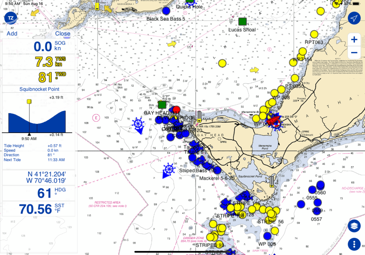
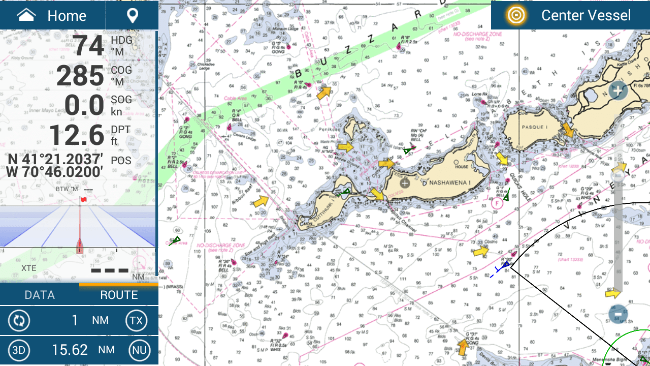
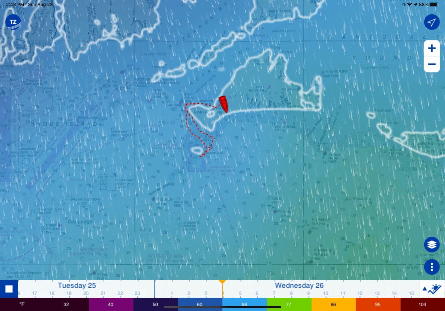
The iBoat chart display itself looks quite similar to a TZT plotter, as can be seen by comparing the raster chart seen on my iPad above with the same general area seen on my TZT3 16 below. (Note that I reviewed my boat’s extensive new Furuno system in July.)
For someone who has a TZT2 or TZT3 on their boat, the close integration makes TZ iBoat really the only app worth using. Not only is the interface familiar but more importantly, the TZ iBoat app can maintain a synchronized copy of all waypoints and routes. Moreover, if you use the “create local network” function on the TZT2 or 3 and then join that WiFi network with your iPad, TZ iBoat will have access to much of the boat data that MFD sees. For example, as shown in the data boxes on the iPad screenshot above, the app is using the high precision speed and course info from my TZT3 as well as the wind speed and sea temp from my boat’s NMEA 2000 network.
As a planning aid, TZ iBoat is by far the best iPad app I have used. It works just like a chartplotter, uses NOAA raster and vector charts, and I find that creating , editing, and saving routes is very simple. While the app itself and basic weather forecasts are free, the detailed raster and vector charts require an annual $20 subscription for US areas and more costly subscriptions for areas outside the US. There is also a more detailed premium weather service for $8.99/month that I did not try. If you have a Furuno DRS4W radome which operates over WiFi, you can get an optional module to display it in the app.
With a TZT2 or 3 on your boat, you don’t even have to worry about transferring routes and waypoints to the boat’s navigation equipment because it will be done automatically if the onboard equipment has a WiFi connection. In the absence of WiFi or with non-Furuno MFDs on board, it is still pretty simple to export the routes and waypoints created in TZ iBoat to an SD card and then transfer them to the boat’s MFDs. In addition to the proprietary Furuno/TimeZero TZD and TZX formats, TZ iBoat will export data in the standard GPX format that can be read by just about every chartplotter. Compared to the other navigation apps that I have used. TZ iBoat is more flexible and incorporates more user functions so even if you don’t have Furuno MFDs, it is very much worth considering as a planning aid or backup navigation system.
Another very nice feature of TZ iBoat, and much improved in v2, is the free weather forecast that can be overlaid on the chart screen. The forecast data includes wind, waves, air temperature, rain, currents, and atmospheric pressure. You can also download weather data for offline use when no internet connection is available. The Layers settings menu lets you choose which elements of the forecast are displayed, and although it is possible to show all of the forecast elements at once, I found it easier to view one or two at a time.

air temperature and atmospheric pressure animated wind forecast
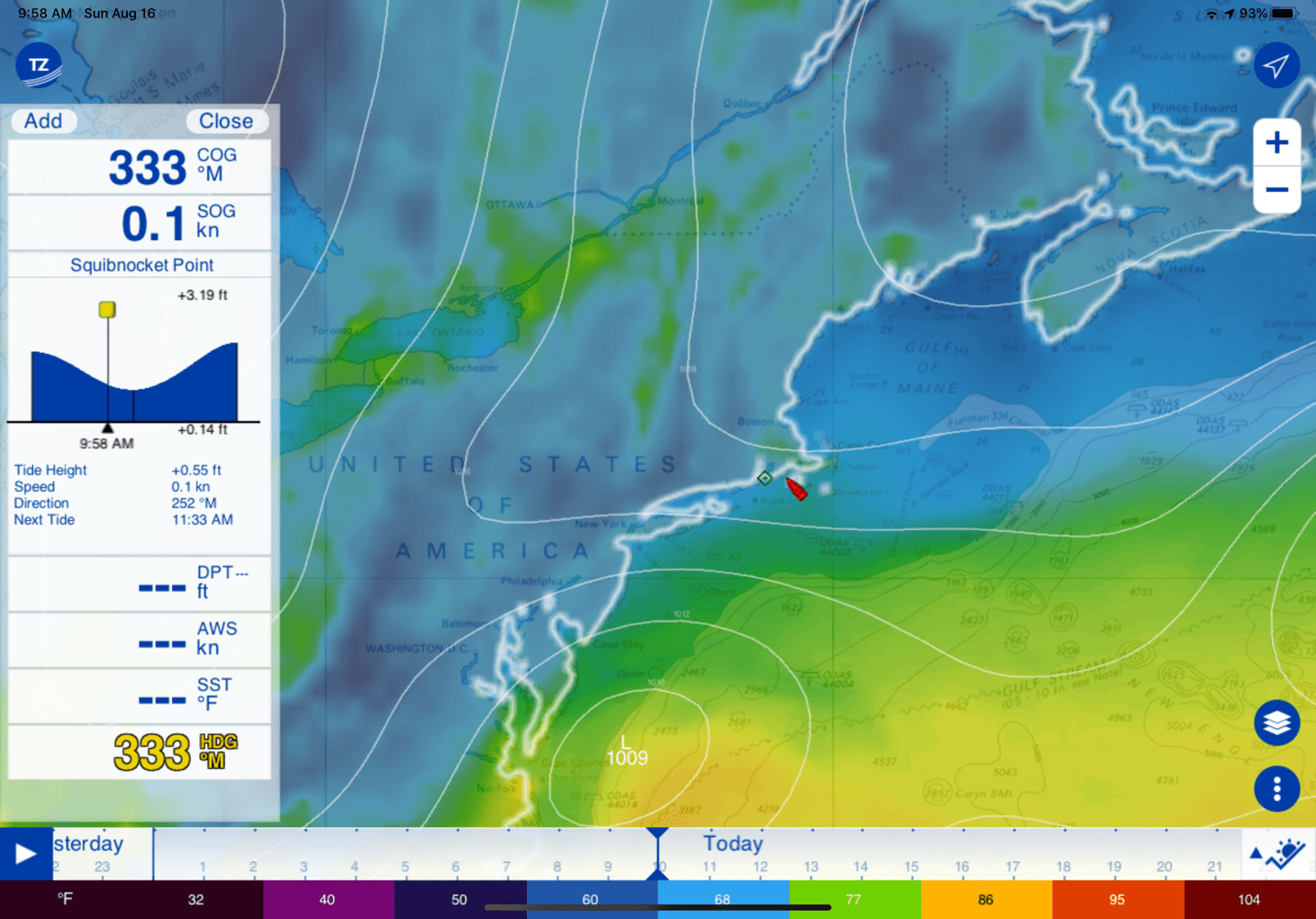
Above is a screenshot of the air temperature and atmospheric pressure for the northeastern US and a much smaller scale forecast of wind, which is Windy style animated when viewed live but can also include traditional wind barbs if desired.
TZ iBoat Weather Layers TZ iBoat metrogram forecast detail of Hurricane Laura
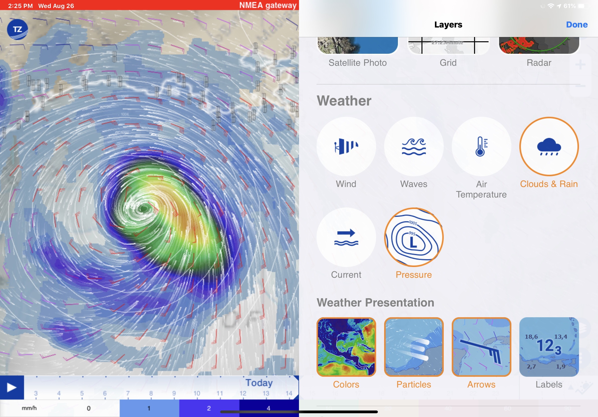
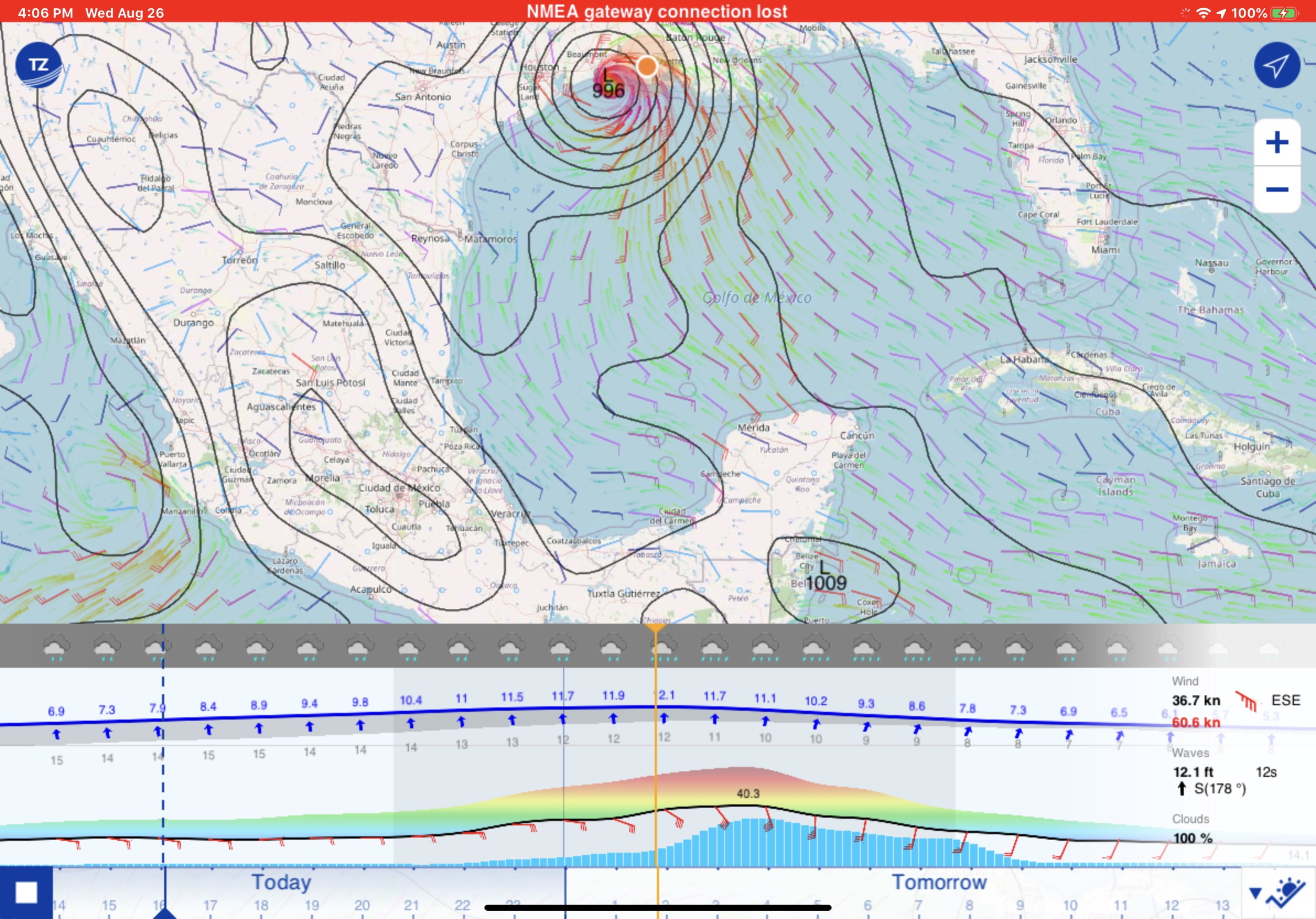
In fact, the app lets you view forecasts in many ways, including a metrogram bar above the time slider. (When online the time slider accesses many days of past and future forecasts, so right now it’s a fascinating way to visualize the “rapid intensification” of Hurricane Laura.)
I think that TZ iBoat would work quite well standalone as a simple navigation tool in a pinch if a regular marine chartplotter is not available. However, using an iPad or iPhone on the boat to navigate from the helm is a real challenge and frankly, I don’t think it’s suitable for regular use at sea. The iPads aren’t waterproof without an expensive aftermarket case and the screen is barely readable in full sunlight. Too much sun heats them up and triggers a protective shutdown. Without an external power supply, the battery won’t last for a full day cruise. I suppose it would be a great thing if you got trapped in fog on your dinghy and could whip out your phone and figure out your location and how to get back, but that’s about it.
On a larger boat, the iPad can be more useful in the salon or lying in your berth. It’s pretty nice to be down below taking a rest while able to check on the person you left at the helm. I am reminded of a good friend who went below for a nap on a long offshore fishing trip and came back to the helm to discover his “relief” crew had disengaged the autopilot to dodge some lobster pots and managed to make a 180-degree turn in the dark and blissfully retraced 25 miles of their route.
All in all, I’d say that TimeZero has created a new benchmark for navigation apps.


How about a big thanks to Fred for sharing his take on TZ iBoat v2 and nav apps in general. I concur with many of his opinions, and am a long time fan of the TZ app, but I’ve also been using some of the other apps recently and there are some terrific features out there.
Navionics Boating, for instance, still seems to have the best autorouting by a long shot, which I find very useful even with my new ability to easily build a route in TZ iBoat and have it instantly appear and activate on the Furuno TZT2 on Gizmo’s fly bridge plus TimeZero Navigator running on a PC at the lower helm. Plus, Boating now has some interesting chart alternatives besides SonarCharts, like Relief Shading, and its ability to get boat data like AIS and Depth over WiFi seems to be more stable than it was for me when it came out last year. Boating can also Plotter Sync with some MFDs and can export GPX files.
Navionics Boating, Garmin Active Captain, Aqua Map, and other apps also have the Active Captain Community data that many boaters value for planning, while TZ iBoat does not.
And while I hesitate to mention it, there’s a Coastal Explorer iPad app in beta testing that comes remarkably close to duplicating the elegant CE computer charting program that has long served many of us well. There isn’t a planned release date yet, but I’m liking the beta a lot. For instance, while iBoat v2’s new weather features are excellent, the CE app delivers what I typically go to first for local cruise planning — the NOAA text forecasts for my area (and sometimes adjoining areas), the nearby weather buoy conditions, and NEXRAD if rain is on tap.
At any rate, there are many good nav apps and sometimes reason to use more than one.
PS Gizmo is down to one radome these days — the nearly incomparable Furuno DRS4D NXT — but my iPad, like Fred’s, is a nav app extravaganza:
Oh no, I missed a few!
Great article, Fred, thanks for sharing your thoughts. I agree with much of your commentary, especially about the drawbacks of trying to substitute an iPad onboard for a dedicated, marine-grade MFD. Sometimes, you get what you pay for….
Good article, Fred and always nice to see a new app, but I’m not impressed . . . yet. First, after downloading it, it’s very awkward to just get started! No menu, no map, no settings and no tutorial, so I wrote them a short “how do I get this started” message.
Second, it doesn’t appear to have the features I really want in a boating app. Auto routing is a MUST for me, which I use on most trips over 5 miles or so, both on Navionics and my Simrad plotters. Works fast and easy, and MUCH faster than putting in one wpt at a time. And, I really like the Sonar charts… especially finding anchoring spots off the grid. Not perfect, but saves a LOT of time.
My second “go to” mapping is AquaMap… just lot more info, especially info on land. And easy to handle wpts, and a great display.
Active Captain is also a must, but is interfaced on most apps, so rarely an issue.
And still have a bunch of others including the old Garmin Blue charts.
However, glad to see this app come out. I’m sure there will be improvements and we can watch for them.
===
As for the IPad replacing plotters, I’m also on the page that says plotters are necessary. But could argue that perhaps more Ipads and fewer plotters would get the job done.
I think we all have somewhat differing ways of using electronics, which is why it is great that we now have four major brands from which to choose. It’s funny how different people are about features. I had autorouting available on the Garmin 8617 MFDs I used to have and hated it. I stopped using it after a few tries because it would make some poor choices and going over and reviewing the route was just as much effort as building a route is on the Furuno TZT 3. I also think Garmin did not do any of us a favor in acquiring Active Captain and agree it is unfortunate that Furuno no longer supports it on their plotters. .
Perhaps I should have been more emphatic in noting that some of the most positive aspects of TZ iBoat relate to the Furuno “ecosystem” and will be less valuable to someone who uses and is accustomed to Simrad or another manufacturers’ products.
Fred,
What did you not like about Garmin’s autorouting? Did it just do a lousy job? Reason I ask is that I’m boat shopping and want to keep that feature in mind for future chart plotters. My Simrad autorouting was excellent, but not perfect. It would occasionally run me aground, but extremely rare. Seems to be flawless about 95% of the time and the AP would just follow if (if there were no other boats).
So, if the Garmin is not up to snuff, I’ll stay with Simrad. Not sure about Raymarine, but believe they also have autorouting.
Hi Larryo, Many Simrad MFDs support both C-Map and Navionics autorouting, so if you were using the latter, the algorithms are similar to what you see in Navionics Boating (and very good in my experience).
By contrast, I’ve fairly often seen Garmin autorouting ignore dangerous ledges here in Maine and make other mistakes further south. And that includes the brand new top of line Garmin system owned by the Ethernet inventor I wrote about a few weeks ago.
But then again, Garmin owns Navionics, so it seems quite possible that the excellent Navionics autorouting will eventually get into Garmin plotters.
By the way, by default Navionics Boating sends user tracks as well as depths along the tracks to Navionics (for SonarCharts), and I strongly suspect that Navionics uses those tracks in their autorouting, which is one reason it’s so good.
Larryo, If you go to the TZ iBoat v2 main menu (TZ icon upper left), and then to About, you can “Show Tips” which are moderately useful for understanding what’s behind the minimalistic interface buttons.
Also if you go to Initial Setup in the same menu, you can turn on “Demo Mode” and then if you tap the Boat Icon (upper right) you’ll find yourself going 6 knots off downtown Miami with charts and even radar overlay.
Finally, one of my favorite iBoat features is the photo fusion satellite layer. The sat photos on land are very high resolution and in shallow areas they’re allowed to show thru under the chart information. Quite beautiful looking, I think, and sometimes darn useful. For instance, check out the marina and shallow reef detail around Miami.
Thx much Ben… I can’t even get the app opened! Can’t get past the welcome screen. Wants me to add a “catch” or photos, which I just don’t see the point.
Just a heads up that I think the link to Fred’s July Furuno article is incorrect and should be https://panbo.com/furuno-tzt3-on-the-water/.
Regardless, nice write-up!
Thanks, James. The link mistake was my bad and is now fixed!
I like this app, and it’s integration into Furuno. It’s feature-packed with excellent tools.
Now, one big issue I have is with the vector charts. A heads up to anybody purchasing for Lake Huron(Georgian Bay). They are missing information in sections of the charts; I don’t mean a few depth values; I’m talking complete areas with no data. Also, there is minimal info on marinas/gas docks compared to Navionics.
I’ve contacted Nobletec about the issue, and they told me they are working on it. They recently switched to official CHS Vector data for Canadian water (to get the most up to date chart correction directly from the official Hydrographic Office)
TZ iBoat (MaxSea TZ for iPad) is our most used charting program, because of its stitched official national hydrographic office raster charts. We’ve relied on it in Canada and in Europe, because for us nothing beats an official paper-like chart.
In 2019, however, TZ did not offer a raster chart for Norway. Enter Weather4d, which also offers stitched official hydro office raster charts. We subscribed to the full Norwegian set for one year for a reasonable price.
We still keep around Garmin BlueChart because we have this amazing continuous chart that covers from the Aleutians in the Pacific to Sardinia in the Med and from the Ecuador-Colombia border in the Pacific to the Shetland islands NE of Scotland. Contrary to much gnashing of teeth, people who ever downloaded it can still download the app and any maps they ever bought; but it only runs flawlessly on iPads and iPhones with iOS 12 or earlier.
I’ll link below to our chart library. In each app shown we have charts that cover at least part of wherever we have been since 2014. We have never purchased anything from the new C-MAP but its online charts work very well while in cell range, which for our boat, is out to at about 10 NM offshore. In the old C-MAP (Plan2Nav) we have charts for the Western Med we purchased a few years ago for cheap but the C-MAP charts were awful and we hardly used them.
We always sail with at least two iPads on and have been known to light up three (e.a. with a different chart from a different provider) because we constantly cross-check the charts. Again, the best are the ones from TZ.
Here’s the photo. Ben, the link works, if nothing displays, perhaps you can look at the embedding code? Thanks.
Sorry, Xavier, the only think I could get to work is that “href” URL link… Here’s the photo
Though I can also upload the image to Panbo and display with “img src” tag. Wish commenters could do similar.
Thanks!
TZ after all these years on the market TZ still have issues with finding the GPS port.
It was the same with VNS and Admiral. The right com port where U-blox software detects GPS TZ does not find or accept. So a solution is this:
– If the COM port does not appear in the list, (…) If you feel that TimeZero
Professional is not listing an existing COM port, press and hold the CTRL key and click.
But TZ does not remember this so it has to be done everytime.